So the Classic Inca Trail hike to Machu Picchu is world-famous yeah? But heads up it’s also one of the more demanding treks you can do here in Peru. You’re dealing with some serious altitude changes the average climb each day is around 1,000 meters (about 3,300 ft) and the highest point you’ll hit is a pretty staggering 4,215 meters (13,828 feet). This is exactly why booking way in advance is key – not just to get a permit but so you actually have enough time to train and get your body ready for the Inca Trail’s altitude challenge.
Inca Trail Altitude – The Big Challenge
A lot of hikers find parts of the Inca Trail tough mainly because of the high altitude passes and some really steep sections. Getting your body used to the altitude (acclimatizing) before you start hiking is super important especially if you live somewhere flat near sea level. Don’t brush this off it makes a huge difference!
How High Does the Inca Trail Get?
The trail itself ranges quite a bit in elevation. It starts lower down but climbs way up going between about 1,000 meters (3,280 feet) and that maximum of 4,215 meters (13,828 feet).
The highest point is famously called Warmiwañusqa or ‘Dead Woman’s Pass’ sitting right at that 13,828 feet mark. Just for perspective that’s almost twice as high as the city of Cusco (approx 11,152 ft / 3,399 m)! You normally tackle this big pass on Day 2 of the trek and yeah it can be pretty challenging for sure.
Even though you hit that big peak the average altitude you’ll be hiking at across the four days is maybe around 3,000 meters (about 9,840 feet).
(Map graphic would typically be here)
How Long is the Inca Trail?
The Classic Inca Trail is considered one of the world’s great (and tougher) multi-day hikes. You’ll cover about 26 miles (or 42 kilometers) over the four days hiking through Peru’s incredible Andes mountains. Of course reaching that max altitude of 13,828 ft (4,215 m) means there are plenty of challenges waiting for hikers who take it on.
Inca Trail Elevation Day by Day
Here’s a rough breakdown of the altitude changes each day:
Day 1: Getting Started
| Stat | Feet | Meters |
| Max Elevation (Camp) | ~9,842 ft | ~3,000 m |
| Approx. Elevation Gain | ~1,640 ft | ~500 m |
| Approx. Elevation Loss | ~164 ft | ~50 m |
- The hike usually starts at a place called Km 82 (around 8,924 ft / 2,718 m).
- You’ll hike to the first campsite often Wayllabamba (at 9,842 ft / 3,000 m).
- Some groups might camp a bit further at Ayapata (higher altitude approx 10,826 ft / 3,300 m).
- Today you pass some interesting smaller Inca sites like Patallacta visible from the trail.
(Image: Hiking Day 1)
Go at your own pace!
Day 2: The Big Climb (Dead Woman’s Pass)
| Stat | Feet | Meters |
| Max Elevation (The Pass) | 13,828 ft | 4,215 m |
| Approx. Elevation Gain | ~3,610 ft | ~1,100 m |
| Approx. Elevation Loss | ~1,970 ft | ~600 m |
- This is usually the toughest day. You climb up and over Dead Woman’s Pass the highest point of the whole trek. It’s a slog but making it feels amazing!
- You might take a break before the top at Lluluchapampa (around 10,829 ft / 3,800 m).
- After the pass you head down to camp usually at Pacaymayo Alto or Chaquicocha (both around 11,811 ft / 3,600 m).
- Keep an eye out for views of the massive snow-capped Salkantay mountain (20,574 ft / 6,271 m) in the distance if the weather’s clear. Salkantay itself isn’t on the Inca Trail but it dominates the skyline.
- You also cross a second smaller pass near the Runkuracay ruins (approx 12,959 ft / 3,950 m) today.
(Image: Climbing steep section)
Hiking poles can really help on the steep parts!
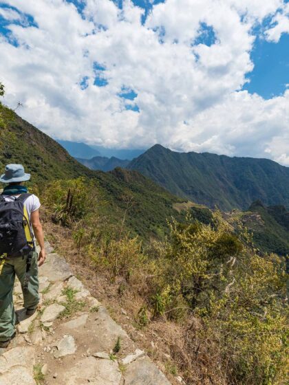
Day 3: More Ruins Downhill Views
| Stat | Feet | Meters |
| Max Elevation (2nd Pass) | ~13,123 ft | ~4,000 m |
| Approx. Elevation Gain | ~1,476 ft | ~160 m |
| Approx. Elevation Loss | ~3,280 ft | ~1,000 m |
- Day 3 is often a favorite loads of incredible views and fascinating Inca sites. You cross the second pass Runkurakay Pass (about 13,123 ft / 4,000 m).
- You’ll get to explore ruins like Sayacmarca (around 11,811 ft / 3,600 m) often perched dramatically on ridges and Conchamarca (11,646 ft / 3,550 m).
- You’ll pass through Phuyupatamarca (‘Cloud-level town’ near 11,975 ft / 3,650 m) which often has stunning views when clear.
- There’s a lot of downhill walking today heading towards the final campsite typically at Wiñaywayna (lower down at 8,530 ft / 2,600 m). This campsite is right next to spectacular ruins of the same name. You might also pass the Intipata ruins (9,317 ft / 2,840 m) terraces.
(Image: Wiñaywayna ruins)
Wiñaywayna Ruins are amazing
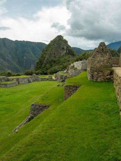
Day 4: Reaching Machu Picchu!
| Stat | Feet | Meters |
| Max Elevation (Sun Gate) | ~8,858 ft | ~2,700 m |
| Approx. Elevation Gain | ~1,476 ft | ~160 m |
| Approx. Elevation Loss | ~492 ft | ~150 m |
- Super early start today to get to the grand finale!
- You hike a couple of hours to reach the Inti Punku or Sun Gate (at 8,858 ft / 2,700 m). This is where you usually get that breathtaking first panoramic view of Machu Picchu spread out below. It’s a real ‘wow’ moment totally chévere.
- From the Sun Gate it’s about another hour hiking down into the Machu Picchu citadel (7,972 ft / 2,430 m) itself for your tour and exploration time.
- The famous peaks right by the ruins are Machu Picchu Mountain (10,111 ft / 3,082 m) and the iconic pointy one Huayna Picchu (8,835 ft / 2,693 m). You might also see the distant snowy giant Pumasillo (19,656 ft / 5,991 m) on a clear day.
- (Note: Some texts mention Puente Ruinas camp (6,561 ft / 2,000 m) this is usually part of longer 5-day treks not the standard 4-day Classic).
(Image: Arriving at Machu Picchu)
Day 4’s reward: the amazing Machu Picchu
How Hard is the Inca Trail Really?
So yeah it’s an epic trek no doubt but it is challenging. You need to be prepared for:
- Steep Sections: Some parts are really steep like over 30% grade going both up and down. Knees feel it!
- Altitude Effects: The air is thinner up high. This can cause shortness of breath headaches tiredness or even nausea (soroche) for some people especially if not acclimatized.
- Physical Demand: It requires a good level of fitness to hike for several hours a day for four days straight with significant elevation changes.
But seriously don’t get freaked out. Most people who are reasonably fit train a bit beforehand and acclimatize properly have an incredible experience and manage just fine.
(Image: Hiker looking tired but happy)
Watch out for altitude sickness
Dealing with Altitude Sickness (Soroche)
Altitude sickness sometimes called soroche here is a real thing. It often affects travelers who go up to high altitudes (usually above 8,200 ft / 2,500 m) too quickly. Symptoms can include: headache nausea dizziness fatigue and shortness of breath.
Acclimatizing before the trek is the #1 way to prevent it. Spend at least 2-3 days in Cusco or the Sacred Valley taking it easy before you start hiking.
Other tips:
- Have the right gear especially layers to handle temperature changes.
- Some find coca tea (mate de coca) helpful (it’s legal and common here).
- In some cases prescription altitude medication might help talk to your doctor about this before your trip.
(Image: Coca leaves or tea)
What’s the Weather Like?
The Inca Trail is in the Andes which means mountain weather:
- Variable: It can change super fast sun to cloud to rain maybe even hail sometimes all in one day.
- Temperature Swings: Days can be sunny and warmish especially at lower altitudes. But afternoons cool down fast and nights get COLD especially at the higher camps (think freezing or below).
- Layers are Key: You need clothes you can easily take off or put on.
(Image: Inca Trail with clouds)
Dry season is highly recommended
Hiking in the Rainy Season (December – March)
- Expect rain often heavy. Trails get muddy and slippery.
- Daytime temps might be around 64°F (18°C) nights cooler 48°F (9°C).
- Remember: The trail is CLOSED all of February.
- Pro: Far fewer hikers more peaceful.
- Con: Wet muddy potentially cold hiking. Need excellent rain gear and waterproof boots.
(Graph: Average rainfall)
Hiking in the Dry Season (May – September)
- Best chance for clear sunny days less rain (but showers still possible!).
- Day temps around 61°F (16°C) but nights can drop below freezing 32°F (0°C).
- This is peak season MUST book permits months in advance.
- Pro: Dry trails clearer views usually.
- Con: Very cold nights much more crowded trail and Machu Picchu.
(Graph: Average temperatures)
Hiking in the Shoulder Seasons (April-May / September-October)
- Often a good mix. Milder temps than coldest dry season nights not as much rain as wet season.
- Weather can still be unpredictable but generally pleasant hiking conditions.
- Still popular so book ahead but maybe slightly less crowded than June-August.
(Image: Camping scene)
How to Get Ready for the Trek
- Train Your Body: Get used to walking! Hike regularly for 1-2 hours maybe more building up distance. If you can find hills or stairs climb them. Get your legs and lungs ready.
- Eat Well: Healthy food gives you energy focus on carbs and veggies in the days leading up.
- Get Good Gear: Comfortable broken-in hiking boots are non-negotiable. Get good quality rain gear (jacket and pants) and a decent backpack that fits well. Good gear = happier hiker.
- Book Way Ahead: We keep saying it ’cause it’s vital. Permits sell out super fast months in advance. Book through a licensed agency as soon as you have your dates!
(Image: Hiking boots backpack)
Check tips for physical preparation
What to Do While You’re Hiking
- Listen to Your Guide: They’re experienced follow their instructions for safety and timing.
- Go Your Own Pace: Don’t try to keep up with the fastest person hike at a speed that feels comfortable for you. Take breaks often.
- Drink LOTS of Water: Staying hydrated is super important at altitude. Keep sipping throughout the day.
- Use Toilets When Available: Facilities are limited use the designated spots when you can.
- Stay on the Path: Don’t take shortcuts cutting corners damages the fragile environment and ancient paths.
The Inca Trail experience is amazing direct contact with nature history challenge adventure and that incredible reward Machu Picchu waiting at the end. If you prepare well respect the trail and listen to your body you’re likely to have an unforgettable trip. Enjoy the journey!
No comment yet, add your voice below!